Into the forbidden kingdom Mustang
BY Louise Southerden —
‘As far as I could see, there was not a single blade of grass, a tree or a bush. Just one gullied expanse of desolation combining the horrors of desert and high, arid mountains, of barrenness and cold. A terrible wind whistled in my ears, spitting sand as it whipped across this parched landscape, howling in the canyons and buffeting the hills, carving them into sinister towers bleached like dry bones.” So wrote French anthropologist Michel Peissel in 1964, one of the first known Westerners to visit the Himalayan kingdom of Lo, now called Mustang.
The land is still as bleak and beautiful as Peissel described. Light, earth, sky, wind – these are the elements that make Mustang, that shape and showcase its landscapes.
It’s also a puzzle of a place. In the rain shadow of the Himalayas, north of the Annapurna range and south of the Tibetan Plateau, Mustang has been part of Nepal since the late 18th century but has more in common with Tibet, which surrounds it on three sides. It was a Tibetan, Ame Pal, who defeated warlords, created Lo and in 1380 built the capital, Lo Manthang. Many Lobas, as they’re called, still speak Tibetan and practise Tibetan Buddhism. The name Mustang comes from the Tibetan word “manthang”, meaning “plain of aspiration”.
After China invaded Tibet, and throughout the 1960s and ’70s, CIA-backed Khampa guerillas from eastern Tibet used Mustang as a base from which to launch raids across the border. It was this volatile situation, and its proximity to Tibet, that prompted the closure of Upper Mustang to outsiders between 1965 and 1992. (Upper Mustang most closely corresponds to the once-independent kingdom of Lo. Lower Mustang, the southern part of the district, has long been open to tourism and is on Nepal’s Annapurna circuit trekking trail.)
Even now Upper Mustang, the real Mustang, is a restricted area – you can visit only with a special permit – and accessible only on foot or by horse. The permit fee was reduced a few years ago, from $US700 to $US500 ($480) a person, and the annual quota of 1000 visitors no longer seems to be enforced. Anyway, Mustang is so remote it receives only about 2000 trekkers a year, a drop in the ocean of 70,000 trekkers visiting Nepal every year.
The 15-minute flight from Pokhara to Jomsom, where we start our two-week trek, leaves behind Nepal’s terraced green fields, rushing rivers and rhododendron forests. We fly low between the Annapurnas and the 8167-metre massif of Dhaulagiri, and over the Kali Gandaki, said to be the deepest gorge in the world, before landing on a dusty airstrip 2720 metres above sea level. We’re still in Nepal – to prove it, a snowy 7000-metre peak, Nilgiri, towers over the town – but we’re somewhere else entirely.
To acclimatise to the 2000-metre altitude gain since leaving Pokhara, we have an easy first day: a three-hour stroll to the town of Kagbeni along a dirt road beside the tumbling, glacier-grey Kali Gandaki river. Every few minutes we step aside to let a jeep, motorbike or tractor pass. Kagbeni is busy, too; it’s an earthy, time-worn town that has been a hub for traders and travellers for hundreds of years and now has a “Yac Donalds”, with golden arches on its red, hand-painted sign. But this is all still Lower Mustang.
We enter Upper Mustang the next morning, after showing our permits at the Annapurna Conservation Area office. We’re still on a road but there are few vehicles and already there’s no doubting the scenic calibre of this place.
Trekking in Mustang is like being at sea, only with more dust. There’s an endless spaciousness, punctuated by cathedral columns, crumbling cliffs and towers of rock shaped by Peissel’s “terrible wind”.
At the village of Tangbe, we have a picnic lunch in an apple orchard, where a boy tries to sell us smooth black rocks for 200 Nepalese rupees each. Three dollars for a rock? He opens one up. Inside is a saligram, an ammonite fossil made by a long-extinct marine invertebrate. It’s a postcard from 50 million years ago, when the Himalayas were still under a sea.
On reaching Chele that evening, after walking all day in the dust and wind, we’re relieved to see our tents up and the Sherpas handing around bowls of warm water for washing. Independent trekking in Mustang isn’t permitted, so our group of 12 is accompanied by a support team: a sirdar (boss), four Sherpas, five cooks and helpers, and three horsemen to manage the mules carrying our kitbags, camping gear and food. That night, the cooks bake apple pie for dessert. “Tomorrow, ice-cream!” a fellow trekker jokes. “Please do not expect this in the Himalaya,” says our ever-patient guide, Ramesh, smiling.
He has led this trek 23 times since 1992 and his trip briefings become our nightly entertainment, such is his happy knack for understatement. That night, with four passes to tackle the next day, the highest at 4010 metres, we listen closely. “There will be a tiny climb,” Ramesh says, followed by some “Nepalese flat” and some “gently up, then down”, but overall it will be a “piece of cake”.
The whole trek lies between about 3000 and 4000 metres above sea level, with the highest pass at 4230 metres – not high by Himalayan standards but high enough to cause a few headaches and make us suffer up hills that really would be a piece of cake at sea level.
What’s more challenging is that we walk for seven to nine hours most days. We edge along ledges cut into sheer cliffs, walk through dust storms in dry riverbeds, descend (and climb out of) steep gorges. As we get higher, more brown peaks come into view, stretching northwards all the way to Tibet.
Then there are the villages – green and lovely oases such as Ghami, where we stop for lunch on day four, which is all autumn-leafed poplars, white-walled courtyards, fluttering prayer flags and pink hollyhocks.
We camp in villages, too, usually next to a tea house surrounded by a mudbrick wall, for access to water and a sheltered place to pitch our tents. Our cooks use kerosene stoves so we don’t deplete the reserves of yak dung and firewood, but the tea houses provide cosy havens to eat, talk and relax at the end of the day before we retire to our tents and fall asleep to the jangling of horse bells from our mules in a neighbouring pen.
Mustang’s Tibetan-ness is always apparent. In the villages we see children wearing Dalai Lama pendants (which would be forbidden in Tibet, where images of His Holiness are banned) and there are wall-size posters of the Potala Palace in every tea house. Tibetan women, selling turquoise and silver necklaces, thunderbolts (a Tibetan Buddhist symbol) and prayer wheels, greet us with “tashi delek” instead of “namaste”.
On the trail we sometimes smell juniper incense carried on the wind from a Buddhist monastery, walk clockwise around massive striped chorten straddling the trail and touch the mantra “Om mani padme hum” etched into stones piled up as mani walls.
Late one afternoon, with the group spread across the rocky landscape, I stop to get a fleece out of my day pack and find myself completely alone. There are no villages, no vehicles, no birds, no power lines. Just mountains and valleys and blue sky and white clouds. Even the wind has died away to nothing.
Walking on, I see Charang, Mustang’s second city, framed by strings of wind-shredded prayer flags. There’s something magical about approaching an ancient city on foot alone at dusk. All is quiet. Goats pour down a nearby hillside and I follow them into town just as the sun creeps behind the surrounding peaks, ushering in a cold night.
It’s day five when we arrive at the walled city of Lo Manthang. It’s smaller than I’d expected, about 200 metres by 150 metres, and dwarfed by its grand setting, on a plain 3840 metres above sea level ringed by 6000-metre peaks. When Peissel was here, “man’s last fortress against nature and the changing world” was home to 1200 Lobas whose three-storey, whitewashed houses were so close together he could walk from one flat rooftop to the next. It was also an anthropologist’s dream – just 50 years ago, people here didn’t use the wheel, had never seen matches and believed the Earth to be flat.
Today, the population is closer to 5000 and spills beyond the city walls. Though electricity, jeeps and tractors have come to Lo Manthang, it still feels mediaeval. When we enter through the high wooden gates and wander the cobbled lanes, it’s as if time has stood still; the whitewashed houses are still here, including the king’s palace, where the 25th descendant of Ame Pal resides. In a small and dusty museum, we see a 10 million-year-old mammoth tooth.
Because Mustang was never invaded by China, Lo Manthang’s 15th-century monasteries are the last bastions of Tibetan Buddhist art. Until recently, they had been ravaged by time, grime, earthquakes and neglect. “There were pigeons and rain puddles [in the monasteries],” says a monk who used to play in them as a boy. Now, organisations such as the American Himalayan Foundation help to preserve Mustang’s culture by bringing in Italian fresco painters to work with local people to restore Buddhist murals, and Lo Manthang is soon to be awarded World Heritage status.
On our second day here, we rent horses and ride north of the city to the Chhosar Valley. The wooden saddles covered with thick carpets aren’t very comfortable but at least we can take in the scenery without watching our feet and experience Mustang as the locals do – on horseback. We see more monasteries and hilltop forts older than Mustang itself, but the highlight is exploring Jhhong Cave, which is a cellar-like maze of 40 rooms across four levels with window holes for light, used by pre-Buddhist Bonpa people to hide from bandits 2500 years ago.
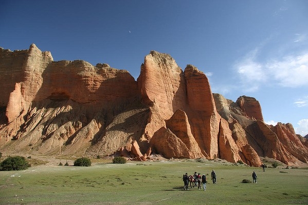
The day we leave Lo Manthang is the longest, highest and most spectacular of the trip. We walk for nine hours, cross that 4230-metre pass and feel as if we are travelling the world: there are craggy Scottish outcrops of dark rock shrouded in mist, Utah-like canyons and rock pillars seen in Jordan. We see meditation caves high up a Cappadocian-like cliff, walk through European meadows (grazed by yaks) and cross a desert that wouldn’t look out of place in Syria. At the village of Dhakmar, high red-earth walls rise from a green lawn smooth enough to putt on; a few of us pose for a photo with our trekking poles, looking like golfers in the middle of a game.
It’s the only day of the trip we see no roads, which makes us realise how Mustang is changing. For the past few years, the road we’d started our trek on, out of Jomsom, has been inching north to Lo Manthang. We see evidence of that almost daily: excavators and bulldozers in remote villages (transported by helicopter), zigzags cut into hillsides, roads to nowhere waiting for bridges to join them.
It’s hard to believe even a basic road can be built in some of the rugged terrain we’ve seen, but in a year or two the journey to Lo Manthang will no longer be a five-day trek but a 70-kilometre drive. That will surely improve life for the people living in Mustang and will just as surely bring other changes. Already a 100-room hotel is being built near Lo Manthang – others are planned – to accommodate tourists who will arrive not in hiking boots but in nice shoes for airconditioned jeep tours.
Another road, completed in 2001, continues north of Lo Manthang into western Tibet, about 15 kilometres away. It’s not open to tourists yet but could offer a scenic day’s drive between Lo Manthang and Tibet’s Mount Kailash, a popular destination for Westerners and Indian pilgrims. More difficult to predict is what will happen when this northern road links with the new Jomsom-Lo Manthang road, creating a trans-Himalayan “highway” that will put Mustang directly in the path of the two fastest-growing economies in the world: China and India. What will this mean for this once-lost kingdom?
Time will tell. Until then, we walk. For the rest of the journey back to Jomsom, we follow our footsteps, walking the same trails we’d walked a week earlier, which is more interesting than it sounds. For one thing, everything looks different when you’re seeing it from the opposite direction, at a different time of day, in different light. We stroll down hills that were tough climbs on the way north. Plus you get howling headwinds when you walk south. That means dust, and plenty of it. “Buff alert!” someone cries on seeing an approaching sandstorm. We cover our noses and mouths, and lean into the gale, laughing as the dust swirls and gives us tans we’ll be able to wash off properly in Jomsom.
For all its apparent timelessness and ancient charm, the winds of change are blowing through Mustang. It’s no longer “one of the last uninvestigated corners of our planet”, as Peissel wrote in the 1960s, and it will change even more, and soon. Before it does, Mustang is like a sleeping snow leopard – all wild beauty, at rest, on the dusty rooftop of the world.
Louise Southerden travelled courtesy of World Expeditions and Thai Airways.Courtesy: www.smh.com.au


